Posts

Showing posts from May, 2024

Rain Then Heat

Image
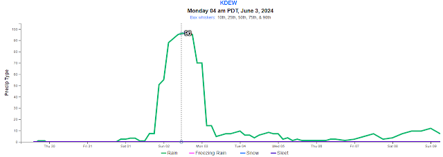
Four days ago (May 26th) I blogged about the potential warm weather pattern taking shape.  I pointed out that there was a lot of uncertainty for the first half of next week, but then the long range models may be converging on warm weather around June 9th.   Two days later, I blogged an update, with the uncertainty early next week resolving itself into a rain event, and the potential heat for next weekend still looking good, but not a sure thing. So I wanted to give you a brief update on both of these events.  First, lets talk about the rain.  The timing still looks consistent with my previous blog, starting around Sunday afternoon and continuing into Monday.  But the confidence of this event is pretty impressive. Here's the familiar graph of the probability of rain for Deer Park.  Note that 96% of the over-100 computer forecasts expect it to be raining at 5am Monday.  That's pretty unusual to see that sort of confidence that far out into the forecast.  As for how much rain to e

Monday Rain

Image
If you read the previous blog, you'll know that we were expecting some showery weather for Tuesday and Wednesday, and that's pretty much what we're getting.  Watch out for frosty temperatures on Thursday morning. But beyond that, we were talking about the uncertainty of the forecast starting this weekend and continuing into next week. Well, the computers are starting to hone in on that forecast a bit better.  And now Monday is starting to look rather wet. Let's look back at a graphic I showed you on the previous blog.  It showed about a 20% chance of rain starting Monday night and continuing through Thursday.  After that, chances of rain were rather low, but not zero. Now let's look at that same graphic two days later.  Notice the differences?  First, the computers are a little more definitive on the showers this week.  But look at how the forecast next week has changed.  Starting Sunday night, the chances of rain really increase, peaking on Monday, and then slowly

Warmer Weather Ahead?

Image
Some of you may be starting to think about that first cutting of hay.  Does the weather forecast look good for cutting hay? For starters, the weather pattern does look like it's going to go through a significant change.  Here's the weather map for yesterday (Saturday).  You can see the cold trough of low pressure over the western half of the country. Just three days later (Tuesday), that pattern is significantly different.  A warm ridge of high pressure has developed in the West.  But there's a cold trough just off shore. By Wednesday afternoon, this off shore trough will move inland.  So the warm 70s on Monday and Tuesday will drop back into the 60s.  Things will also be breezy during this transition, especially on Wednesday. Will there be any rain with this trough?  In short, there will be some showers during the next few days.  None of these showers look really wet, but there is an outside chance of a shower that would be not be nice to a field of mown hay, especially no

Weather After the Rain

Image
Our midweek storm delivered on the much-hoped for rain in our area.  While Spokane had about a third of an inch, the southwesterly winds enhanced the rainfall just to the north of the metro area, as is commonly the case.  Flowery Trail picked up 1.40" of rain In our last blog, I mentioned the potential for a weekend storm system.  The computers are honing in on a confident forecast.  Screaming message: we won't see nearly as much rain as we did from the storm just complete.  The reason?  The map below on the left is from our recent storm.  Notice how the low was "closed" over Washington.  We've talked about this before.  This means the storm is strong and moving very slowly and is a good pattern for rain in the Northwest.  The image on the right is a forecast for Saturday.  Notice there's no closed low.  This storm is weaker and moving faster.  So the resulting rains will be much less. We will see some showery weather on Thursday and Friday as well.  There

Will There be Rain - Update

Image
Just wanted to provide you with a quick update on the chances of rain in the coming days. We’ll continue to see a chance of afternoon showers on Sunday as well as Monday.   Tuesday will be drier as a more significant storm approaches from the west.  As with our last storm, this low will slowly move by just to our south, which is a good pattern for widespread rain   Rain will probably start Tuesday night as the cold front comes through. There will probably be a break in the action. But then more rain should wrap around the low on Wednesday for a cool and wet day.  Here’s a couple of computer forecasts of rain for Tuesday night and Wednesday. As always, the amounts will vary. But right now it looks like we should see 0.25”-0.50”, with a chance of more for some locations, especially in the north.  After this rain event, we’ll see more afternoon showers for the remainder of the week. The computers are pointing to another storm system for the weekend, but the exact track and strength of thi

Cooler Weather Ahead. But Will There be Rain?

Image
You may have seen your phone app advertising cooler temperatures coming up, starting on Friday.  And the app may not be showing any chances of rain, which is kind of odd.  What gives? Here's the current weather map.  Warm high pressure to our west, but a cool low up in northwest BC.  This low is actually going to drop south into our area.  As it does, expect some windy weather on Thursday and Friday. Here's the weather map by Friday.  This should be a good thing if you want rain, right?  Unfortunately, the main low is passing by to the north of us.  Also it's coming from the north, so it doesn't bring a lot of moisture with it.  Dew points are going to drop from the 40s into the 30s and even upper 20s.  As a result, this low will bring some light showers to the northeast Washington mountains, but not much south of Spokane. The good news is that there is another low behind the first, and it too drops into our area.  This will hang out over the Northwest through much of n

Will We See an Aurora Tonight?

Image
The Space Weather Prediction Center (SWPC) is getting pretty excited about the odds of a Northern Lights show tonight (Friday night).  If you're like me, you've seen these alerts before, only to be disappointed by the lack of an aurora.  But tonight might be different. First, I'll start with the Kp Index that the SWPC folks track.  I'll spare you the details.  What you want to know is that this index has had a dramatic jump on Friday morning.  Values over 6 typically (but not always) produce an aurora in the Inland NW.  This morning the value has jumped to nearly 8, and 8.5 this afternoon. SWPC has issued a G4 Watch for tonight.  The last time they did this was in 2005.  So that should tell you that this is an unusually strong event and the folks at SWPC have high confidence. Here's a map from SWPC showing the probability of an aurora.  For the US-Canada border, the odds are very high.  For Washington and North Idaho, the odds are a little lower, but still high.  An

Ready For Some Warmth?

Image
Well, we finally got some much needed spring rain.  But we're still about 3" below normal on precipitation, so we'll be wanting more. Unfortunately, it looks like we're going to get just the opposite for the next 10 days.  A warming and drying trend will start on Tuesday. Here's the weather map from Monday morning.  Our Sunday storm is over Wyoming with more low pressure in the Gulf of Alaska. By Thursday, that low pressure has been replaced by a strong high pressure system centered over Vancouver Island.  This means warmer and dry weather ahead. We'll likely see our first 80F days this coming weekend, just in time for Mother's Day. Looking beyond this coming weekend, high pressure continues to dominate the West.  However, the jet stream in this pattern is pointed into southern BC.  About 10% of the computer forecasts have the jet stream a little farther south, bringing the potential for some showery weather to our region.  Looks like a better chance of rai

Rainy Bloomsday

Image
Since our previous blog, the computer forecasts (as expected) have been trending farther south with our upcoming storm, as has been the case for previous storms this spring.  One key difference that I pointed out in the last blog is that this storm is forecast to move much slower.  Why does that matter? For fast-moving storms, the weather pretty much moves with the storm, from west to east.  But with a slow moving storm, clouds and rain have a chance to rotate around the storm.  So for folks (like us) who are north of the low, the rain actually moves into our area from southeast or east.  It's this pattern that makes May the wettest month of the year for Montana (see a  previous blog on this).  This storm will bring heavy rain to all of Montana. So even though the low is moving by to our south, we still stand a good chance of getting some rain from it.  But rather than coming from Seattle or Portland, our rain will be coming from Boise or perhaps even Missoula. Saturday will be we