Rain Then Heat
Four days ago (May 26th) I blogged about the potential warm weather pattern taking shape. I pointed out that there was a lot of uncertainty for the first half of next week, but then the long range models may be converging on warm weather around June 9th.
Two days later, I blogged an update, with the uncertainty early next week resolving itself into a rain event, and the potential heat for next weekend still looking good, but not a sure thing.
So I wanted to give you a brief update on both of these events. First, lets talk about the rain. The timing still looks consistent with my previous blog, starting around Sunday afternoon and continuing into Monday. But the confidence of this event is pretty impressive.
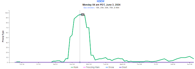
Here's the familiar graph of the probability of rain for Deer Park. Note that 96% of the over-100 computer forecasts expect it to be raining at 5am Monday. That's pretty unusual to see that sort of confidence that far out into the forecast.
As for how much rain to expect, the models have converged on the wetter solution. Here's the rainfall total for the upcoming event using the National Blend of Models, which blends all of the over-100 computer forecasts. 1-3" of rain on the west side, then a rain shadow in the Basin, then around 0.75-1.00" for Spokane and northeast Washington.
It's worth noting that this storm is different than our two May events, which depended on a deep low moving slowly by to our south. This is more of an atmospheric river type of event, so the Basin folks shouldn't expect much from this storm.
Then what about the heat? If you recall from the last blog, the model clusters were about 50% warm-to-hot and 50% not. Now they're 90% warm or hot and only 10% not-so-hot. It's worth pointing out that all 50 of the European models are going for hot weather.
So just how hot? We should reach into the lower 80s by Thursday, mid-80s by the weekend. I've shown you this kind of graph before. The black dot is the "best" forecast (e.g. 85F for Saturday). But the top of the box shows what the hottest 10% of the computers are actually forecasting, while the bottom of the box shows what the coolest 10% of the computers are predicting. You can see that for next Saturday, 10% of the computers are forecasting a high of only 73F, but 10% are forecasting a high of 97F. Given what we saw in the cluster graph above, I'd lean away from the 73F and hedge my bets on the warmer forecasts of mid-to-upper 80s, but noting that even the 90s are possible.
How long will that high pressure last? At least until Flag Day (14 June) if the majority of the computer forecasts are correct. I'll update this blog in a few days to see if anything has changed on these two events.

.png)


Comments
Post a Comment