Snow in the Forecast?
Yes, it’s that time of year again. And if you’ve paid attention to the forecast, you’ve seen the dreaded (or delightful) word: snow. Is there really a chance of it? Actually, there are two chances. At this time of year, timing is critical. If the clouds move in too early at night, we don’t cool down enough for snow. If the precipitation starts too late in the morning, it will be too warm for snow.
So chances are pretty low for snow. And any snow that does fall will have a hard time accumulating, especially on roads. That said, the US computer model the GFS does have a very snowy prediction. To be clear, the temperatures for this event would be in the mid 30s so accumulation is highly unlikely. But the GFS wants to give us several inches of wet heavy snow.
Our first chance of snow will be early tomorrow (Thursday morning). Clouds will increase about 7pm this evening and Precipitation will start about midnight. This isn’t good timing for snow. The wild card in this mix is that the air will be drier, with dew points around 30F, which is good for snow. If there is any of the white stuff on Thursday morning, it’s doubtful it will accumulate on the ground. Steady precipitation should end around 7am with about 0.15” of liquid.
We’ll have a short break before the next, stronger storm arrives Thursday night. The clouds and precipitation will be a few hours later with this second storm. So that bodes better for snow. But our atmosphere won’t be as dry, which favors rain. You can see on the graph below the lower values of dew point tonight vs tomorrow night.
The atmosphere aloft will be slightly colder than the first storm. And this might make the difference for snow vs rain.
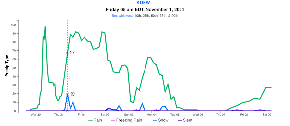
Here’s the rain and snow chances for the next 10 days. You can see other small chances for snow beyond Friday morning. But again the odds are low.
One thing the computers do agree on is that the second weather system on Friday will be rather wet; around 3/4” of moisture. Here’s the computer blended forecast of precipitation for tonight through Saturday. Areas in the light purple color can expect at least 1” of liquid.
Looking beyond these two storms, we can expect another wet front for the middle of next week. With daytime temperatures in the 40s. November weather is clearly here to stay for a bit.


.png)


Comments
Post a Comment