Posts

Showing posts from January, 2024

Was Yesterday the First Day of Spring?

Image
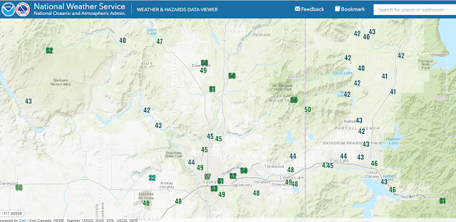
The calendar says it's late January, but the weather feels decidedly spring-like.  Are we done with winter? First, here's a map of the high temperatures yesterday (29 Jan 2024).  You'll note that while Deer Park and surroundings were 50F, a number of other locations were stuck in the lower 40s.  What gives? The answer is fog.  While Deer Park and the Spokane metro area were sunny, other locations were stuck in the fog and low clouds all day.  Here's a satellite image at the end of yesterday.  Note all the "fingers" of fog in northeast Washington and north Idaho.  That fog hung in there all day in many valleys. On a very micro scale, even though it was 51F at my house, about a mile from me there was a shallow fog bank in a creek bed, crossing the road.  As I walked through it, the temperature felt a good 10 degrees cooler. So can we put away the snow shovels and take off the chains?  You probably already know the answer to that one.  We will enjoy one more day

Heavy Snow to End the Cold

Image
It's rather common for arctic cold snaps to end with snow in this region.  The reason?  Well, east of the Rockies, air masses like this one move around fairly freely, since the topography is mainly flat (except for the Appalachian Mountains).  But in the West, our mountain ranges trap and hold on to this cold, dense air.  Eventually, a warmer Pacific storm comes along and tries to push out the cold air.  And usually it often wins.  But not without first creating some snow for us.  And in this case, that has the potential to be a lot of snow. First, we'll start with temperatures.  As I said in the previous blog, we'll continue to gradually warm up, reaching above the 32F mark by the weekend. Our storm will arrive Tuesday night and snow will fall all day Wednesday.  Temperatures during this storm will be in the mid-teens to lower-20s.  Very cold snow, which typically means drier, fluffier snow.  But there have been some instances in these situations where we get more "su

Just How Cold Was It?

Image
 I'm guessing most folks have a thermometer, and were surprised by just how cold it was this morning.  Here's a map of the low temperatures measured at numerous locations. As you can see, -20F and colder was common north of Spokane.  The -38F in northwest Montana was at Yaak. Here's a zoomed in view. Now, as cold as it was last night, it wasn't "unheard of" cold.  Spokane's coldest temperature ever is -30F way back in 1881.  And they hit -24F back in 1996, my first winter here.  Chewelah hit -38F in the winter of 1950.  Newport dropped to -41F in that same event.  So we can safely say that it has been colder. But frigid low temperatures are sort of easy to do around here.  With snow on the ground and a calm clear night, the thermometer can drop pretty low.  What's difficult is to keep the daytime high temperature frigid.  That's a better measurement of how cold the air mass really is.  Keeping daytime temperatures below 0F is tough to do around her

How Much Snow and How Cold?

Image
Forecasting snow amounts is one of the most difficult meteorological endeavors.  And forecasting low temperatures in the winter can be equally tough. For snow, there's so many variables that affect the amount.  The same is true for nighttime low temperatures.  In the upcoming situation, we'll have plenty of fresh snow on the ground, and a Canadian air mass in place.  But clouds, fog and wind complicate matters considerably.  If you live in a sheltered area, you're more likely to be colder than other locations.  But if your area is cloudy, then you won't get nearly as cold.  In these situations, it's easy for a forecast to be wrong by 10 or even 20 degrees. First, we'll talk about the snow.  Storm #2 is still on schedule to spread into the area late Monday afternoon.  Snow will probably arrive before sunset, complicating the evening commute.  This is a stronger storm than Saturday.  The arrival time of late afternoon isn't a good time to start snowing, since

Very Snowy and Cold Next Week

Image
As we discussed in our previous blog, our mild winter weather is coming to an end.  We'll see some light snow tonight (Friday night), but then it should be snowing most of the day on Saturday, with snow showers continuing Saturday night and into Sunday morning.   The European model isn't too excited about the snowfall amounts with this system for the Spokane area (0.7"), but gives a healthy 3-5" to the northern valleys.  It has been very consistent with this forecast over the past couple of days. Meanwhile the GFS is much more excited about this storm, bringing 6" to Spokane and Sandpoint.  The difference is that the GFS lingers the storm over our area much longer than the European model.   There are lots of other models that give us snowfall amounts somewhere between the GFS and ECMWF forecasts above.  With temperatures right around freezing, this snow will be on the heavier wetter side.  Snow-liquid ratio (SLR) will be around 10:1, which means if you get 0.25&q

Turning Colder and Snowier

Image
December was a rather mild month, and that's putting it mildly.  The temperature remained below freezing for only one day in the month, and that was on the 1st.  All the rest saw the mercury rise above the 32F mark each day.  We had several days in the 40s, and we nearly reached 50F on the 5th.  It was the warmest December at Deer Park going back to 1998.  At Spokane Airport it was the third warmest December since 1947. All of this is likely a product of a strong El Nino.   But we're looking at a significant pattern change in the weather.  You've probably already heard about it or seen it on your phone app or TV  broadcast.   Here's what the upper level weather map currently looks like.  You've all seen the storms heading into California recently in the news.  As these storms make landfall south of our area, we only get a weak dying weather front.  But the deep cold area of low pressure over the Aleutian Islands will play a role in our pattern change. By this weeken