How Much Snow and How Cold?
Forecasting snow amounts is one of the most difficult meteorological endeavors. And forecasting low temperatures in the winter can be equally tough.
For snow, there's so many variables that affect the amount. The same is true for nighttime low temperatures. In the upcoming situation, we'll have plenty of fresh snow on the ground, and a Canadian air mass in place. But clouds, fog and wind complicate matters considerably. If you live in a sheltered area, you're more likely to be colder than other locations. But if your area is cloudy, then you won't get nearly as cold. In these situations, it's easy for a forecast to be wrong by 10 or even 20 degrees.
First, we'll talk about the snow. Storm #2 is still on schedule to spread into the area late Monday afternoon. Snow will probably arrive before sunset, complicating the evening commute. This is a stronger storm than Saturday. The arrival time of late afternoon isn't a good time to start snowing, since temperatures will be warming up. But the atmosphere is colder now than it was at the start of Storm #1. Downtown Spokane may start off as wet snow, but it should accumulate on the roads after the sun sets.
Once again, the GFS is the snowier forecast. Here's how much it expects by Tuesday morning.
This strong storm will also push warmth and wind into our area on Tuesday as the snow comes to an end. Wind gusts to 35 to 45 mph will be common, with 55 mph gusts possible in Spokane and the Palouse. Normally this would melt a lot of snow. But dry air moving in may mitigate some of the snow melt.
The atmosphere then gets rather unstable as very cold air moves in above us while temperatures at the surface remain in the 20s and 30s. This will be the recipe for convective snow showers. They'll be most prevalent on Wednesday and Thursday. I could show you some forecasts, but it won't really help as the snow amounts in this period will be rather unpredictable. Snow in this situation is light and fluffy.
After this, cold air from Canada will push into the area from the north starting Thursday afternoon. By Friday morning, cold wind chills are likely, -10F to -20F.
Once the wind quiets down, temperatures will reach their coldest, probably Saturday or Sunday morning. Lows could be sub-zero, again, depending on how sheltered you are and if the skies clear. Daytime highs will in the teens.
Here's a summary of the temperatures and wind chills (dashed line) at Deer Park. But remember, nighttime temperatures could get much colder if conditions are just right.
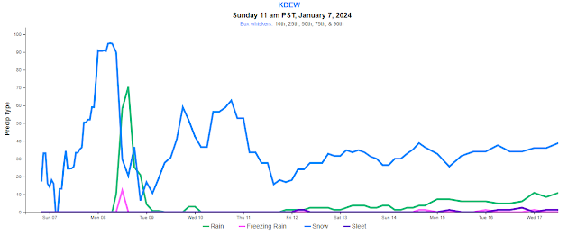
And here's the chances of precipitation for the next 10 days.
.png)
.png)


.png)


Comments
Post a Comment