Was Yesterday the First Day of Spring?
The calendar says it's late January, but the weather feels decidedly spring-like. Are we done with winter?
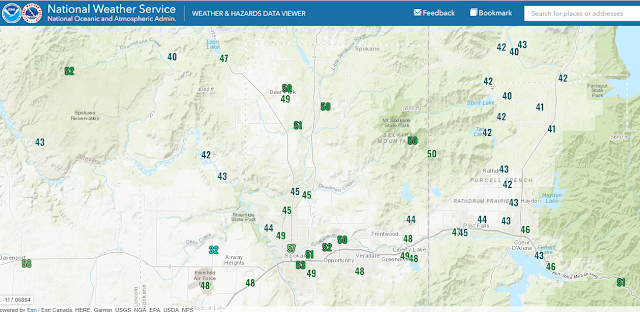
First, here's a map of the high temperatures yesterday (29 Jan 2024). You'll note that while Deer Park and surroundings were 50F, a number of other locations were stuck in the lower 40s. What gives?
The answer is fog. While Deer Park and the Spokane metro area were sunny, other locations were stuck in the fog and low clouds all day. Here's a satellite image at the end of yesterday. Note all the "fingers" of fog in northeast Washington and north Idaho. That fog hung in there all day in many valleys.
On a very micro scale, even though it was 51F at my house, about a mile from me there was a shallow fog bank in a creek bed, crossing the road. As I walked through it, the temperature felt a good 10 degrees cooler.
So can we put away the snow shovels and take off the chains? You probably already know the answer to that one. We will enjoy one more day of mild weather. Then a cold front will bring us some light rain on Wednesday night and Thursday, followed by cooler weather.
Our current weather pattern shows a warm ridge of high pressure over most of the lower 48 states, with cold troughs over the Pacific and Alaska.
What all this means for us in the Inland Northwest is cooler weather. Think lows in the 20s and highs in the 30s to around 40. That's actually close to normal for this time of year. Along with this will come chances of light snow, probably starting around Sunday and continuing through next week. With all of the strong storms going to our south, we'll get the weaker remnants. So we're not looking for any big dumps of snow. Probably an inch or two every so often, although I can rule out a 4" event.


.png)


Comments
Post a Comment