What Happened to our Rain?
Most of you are probably like me, expecting (hoping?) for more rain than we received from this latest storm. Here's the rainfall measurements from around the area. As you can see, just about everyone around received more rain that the Spokane area. This includes the Palouse, central Washington, the Idaho panhandle and western Montana.
This was well below what we were expecting. But a few of the computer models (very much in the minority) were pointing to a much drier forecast than what most were saying. I hope that this drier-than-hoped event didn't impact any of your plans.
We're in a cooler, showery pattern now for the next few days. These will be light afternoon showers, but every bit will help. Monday should have the best chance of getting wet.
You may have heard that Washington state declared a drought emergency in mid-April.
Why such a difference? This is likely explained by the fact that the Drought Monitor folks are constrained to only consider what has happened, and not to factor in what they think will happen in the near future. The Washington state folks are likely not under the same constraint. So their drought declaration may be factoring in outlooks for the remainder of the spring and summer.
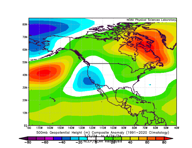
The image below is what we call a pressure anomaly chart. It shows what areas of the continent have had lower pressure than normal (i.e. stormy weather) and what areas have had higher pressure (quiet weather).
For the past 3 months, the Southwest US has had the low pressure anomaly area.
When you look at the percent of average precipitation over that similar period, you can see the largest areas of above-normal rainfall (blue and purple) is in California and Arizona. This matches nicely with the pressure-anomaly chart above.
El Nino is fading from it's mid-winter maximum. But it hasn't gone away yet. And it's still impacting our overall weather pattern. One of the main pattern changes due to El Nino is a jet stream that is displaced farther south than usual, pointing at California instead of the Pacific Northwest. This matches what we see in the above diagrams.


.png)
.png)


Comments
Post a Comment