Posts

Showing posts from December, 2023

Odds of a White Christmas - Update #2

Image
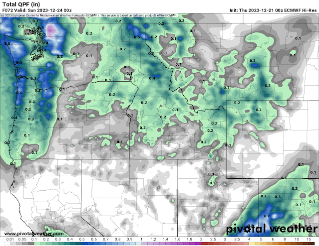
As we started off this set of blogs, strong El Ninos are not the most likely winters to have white Christmases.  And unfortunately, that appears to be the case this year.  If you still have some snow on the ground, then you may still be able to hold on to a white Christmas.   We'll get some more rain on Friday, though not as much as earlier this week.  The timing of the system is poor, with it's arrival in the afternoon.  Were it in the late night or morning hours, we might have been able to eek some snow out of it.  Here's how much precipitation the European forecast model expects.  This will be snow in the mountains, but rain for us here in the lower elevations. As the cold front sweeps through the area on Friday evening, it will get a little breezy, which isn't good for keeping snow on the ground.  But dry air will be coming in behind that front which hopefully will help mitigate the snow melt.  It's possible that some of that rain will change over to snow with t

Odds of a White Christmas - Update #1

Image
 As we discussed in our previous blog about White Christmas, the odds are typically low in an El Nino winter, and this one is no exception.  That said, if Christmas arrived tomorrow, a fair number of you in the Inland NW would consider it a successful White Christmas.  I'll show you two maps.  The first is actual observations of snow depth on the ground, taken by observers just like you. It shows for those locations that reported, a few inches of snow are still on the ground across the northern valleys and even in spots of the Spokane/CdA metro area. The second is a computer attempt to display these observations along with other data.  After taking a drive yesterday, I can tell you that the gray area in the map below is pretty spotty when it comes to snow cover. So how does the forecast look for getting more snow, or at least holding on to the snow we currently have?  The odds aren't great, but there is a ray of hope. The next chance of precipitation will arrive around Tuesday.

The Earliest Sunset of the Year

Image
I'm guessing that most of you, after reading the title, would guess that this event will occur on the winter solstice, typically December 21st.  But it's a strange little quirk that while the winter solstice is the shortest day of the year, it doesn't have the earliest sunset (or latest sunrise).  The reasons get pretty technical and probably not of much interest to most (see this link for more info).  They include that: A day is technically not exactly 24 hours long. The earth is not an exact sphere. Sunrise and sunset are measured by the top of the solar sphere and the horizon, not the center of the solar sphere. In any event, the date of the earliest sunset is actually determined by latitude (i.e. how far you are between the earth's equator and the pole).  This figure from Stephan Aman shows this nicely.  So if you think it's strange to have our earliest sunset 10 days before the shortest day of the year, think about how folks in Key West, FL feel, where their ea

Odds of a White Christmas

Image
Yes, Christmas is still more than 2 weeks away.  So it's kind of a stretch to be talking about White Christmas odds.  But since the computer weather forecast models make predictions out to 15 days in the future, we do have some educated guesses we can talk about. First, we should start with climatology.  On average, how often do we get a White Christmas (defined as at least 1" of snow on the ground)?  By now you've probably seen this map that the National Weather Service put together about a dozen years ago and has updated.  It shows the historic probability of a White Christmas (not a forecast for this year on any year). First, a few observations. The vast majority of the lower 48 states have very low probabilities of  a White Christmas for any year. The highest odds of a White Christmas are actually in the high mountains of the western US (but not too many folks live there). The Inland Northwest is actually one of the better places for having snow on the ground on Decemb

Rain Storm Recap

Image
The cold front moved through overnight to bring an end to the steady rain.  A rather wet 3 days that we'll put into context in a minute.  First, here's a map of the 72 hour rainfall totals (Monday morning to Thursday morning, 4-7 Dec 2023). Obviously western Washington received the most rain.  But you can also see that northeast Washington and north Idaho picked up some impressive totals as well.  It's pretty easy to see where the Atmospheric River was pointed.  But this area is also favored when the flow pattern is from the southwest, as it was in this situation. A closer zoom of the area shows some interesting details worth noting. Deer Park airport picked up 2.74" while Spokane airport received only 1.34". Big Blue RAWS (on the Spokane reservation) received 3.78". The wettest observation is 9.00" at Hidden Lake SNOTEL (5000' elevation) west of Bonners Ferry. Bear Mountain SNOTEL (east of Sandpoint) had 6.50". Bunchgrass Meadows SNOTEL (east o

What is an Atmospheric River?

Image
You may have recently heard the term "Atmospheric River" and wondered what exactly is meant by that.  I won't get too technical so I don't bore you.  But I thought a short blog would help some curious readers. First, an Atmospheric River (or AR) is a relatively new term in the field of meteorology.  Research aircraft flying through Pacific storms off the West Coast helped to identify this phenomena.  And actually, it's rather common. Here's an excellent satellite image of the Pacific Ocean.  This image doesn't show clouds like most satellite pictures, but rather it shows moisture in the atmosphere. A couple of things to point out in this image.  The vast majority of moisture in the atmosphere is found over the tropics near the equator.  This is indicated by the orange colors.  But you'll also note strips of moisture emanating from the tropics up into the middle latitudes (light blue and yellow colors).  These are the atmospheric rivers.  As storms come

Ready for Some Rain?

Image
Our multiple storms delivered the promised snow over the past few days.  Now that you have your driveway neatly plowed and your walkways shoveled, you can sit back and watch it rain.  And we could be talking about a lot of rain.  Temperatures will also rise into the 40s for much of the week and not go below freezing at night.  Add some breezy winds at times, and we should see some of this snow melt away. Below is a summary of precipitation probabilities for the next 10 days (top graph) and the precipitation amount expected (bottom graph). Starting from the left side, you can see we have a few hours of snow in store today, starting about 10 am.  This will probably change to a little light rain before sunset.  Then look at the huge probabilities of rain starting Monday and continuing through Thursday.  It's not going to rain continuously for four days.  There will be some breaks, just impossible to forecast at this time. The bottom graph shows that we could see 2" of rain or mor