The forecast for the upcoming snow is still pretty similar to my previous blog, but now we can give a bit more detail on the timing and potential amounts.
Our cold and dry atmosphere that we’ve had for the past few days will guarantee that precipitation will start as snow. As I said in the previous blog, the first front after a dry spell is often weak and we don’t get a lot of precipitation from it. Thursday looks to be dry. Snow will start Thursday night. Road surfaces should be sub 32F when the snow starts. So I wouldn’t expect that they will be icy on Friday morning.
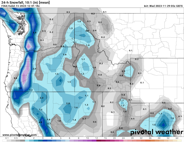
Here’s the US model ensemble 24 hour snowfall forecast for Friday morning. Don’t get too hung up on the exact amounts and placement. The screaming message here is that snow amounts will be light, probably around an inch.
The second wave will follow quickly on the heels of the first, so there may not be a discernible break. This wave will bring more moisture and warmth. Snowfall amounts should be higher. With rising temperatures, the snow will be wetter and heavier. It should taper off by late Saturday morning and may even change over to rain at the very end.
Here’s the US model forecast for snowfall for Friday afternoon through Saturday morning. Again, the main message is that there will be more snow in this time period than from the first front.
More storms are expected to follow these first two. But since the warm front on Friday night pushes our cold air out of the area, subsequent storms will be mostly rain with rising snow levels. You can see this transition from snow to rain in the graph below. The blue line on the left side of the graph shows that the most likely precipitation type will be snow. But during the weekend, the green line shows that rain is also a possibility. By next week, rain is the only precipitation type.
Temperatures next week will rise into the 40s with significant rainfall possible. In other words, the snow that falls from these first few storms may mostly melt away a few days later. And this is the typical expectation for a mild El Niño winter.


.png)


Comments
Post a Comment