Posts

Showing posts from November, 2023

Snow on the Horizon - Update

Image
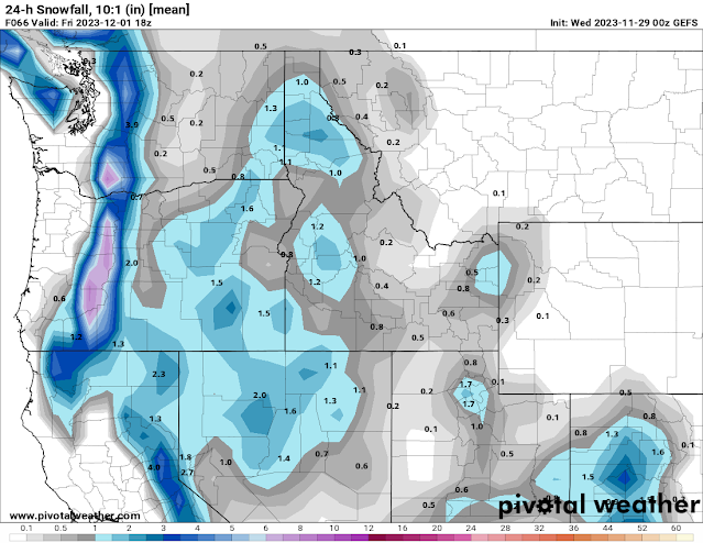
 The forecast for the upcoming snow is still pretty similar to my previous blog, but now we can give a bit more detail on the timing and potential amounts.  Our cold and dry atmosphere that we’ve had for the past few days will guarantee that precipitation will start as snow. As I said in the previous blog, the first front after a dry spell is often weak and we don’t get a lot of precipitation from it. Thursday looks to be dry. Snow will start Thursday night. Road surfaces should be sub 32F when the snow starts. So I wouldn’t expect that they will be icy on Friday morning.  Here’s the US model ensemble 24 hour snowfall forecast for Friday morning. Don’t get too hung up on the exact amounts and placement. The screaming message here is that snow amounts will be light, probably around an inch.  The second wave will follow quickly on the heels of the first, so there may not be a discernible break. This wave will bring more moisture and warmth. Snowfall amounts should be higher. With rising

Snow on the Horizon

Image
Like this morning, we're looking at a few sunny days and cold nights through mid-week.  Then, the weather pattern will change.  This pattern will be more "traditional" for our area, so the impacts are more likely to be predictable. The first Pacific wave will reach our area on Thursday night.  When this storm hits our current cold and dry air mass, the resulting precipitation will almost assuredly be in the form of snow.  The problem is, the first wave to make landfall is usually weak.  So snowfall amounts are generally light.  In fact, some of the computer forecasts don't bring any precipitation at all with this first wave.  Here's an example snowfall forecast from one computer, for Thursday night and Friday morning. A second wave will come in right on the heels of the first wave.  Temperatures will be warming, so the snow will be heavier.  Here's a couple of example forecasts for snowfall amounts.  Remember, these are just a couple of guesses at this point. 

Turning Colder but Dry

Image
The weather pattern is looking much quieter for the rest of November 2023.  A weak Pacific front will move through the area on Wednesday, just before Thanksgiving.  This front is coming from the northwest, which is not favorable for precipitation for locations north of Spokane.  And since the system is weak, precipitation amounts will be light.  Although the timing of the precipitation is during the morning hours (when snow would be favored), the atmosphere aloft is going to warm up before the front arrives.  So precipitation type should be rain for the valleys.  Here's one model's forecast of the precipitation amounts for Wednesday. This weather system will move into the Great Basin for the end of the week.  Meanwhile, very strong high pressure will develop along the west coast of Canada.  This pattern will do two things.  First, Pacific weather systems will have to go around this high pressure, keeping the Inland Northwest dry for several days, possibly through the end of the

Mild Thanksgiving

Image
 In my last post on Sunday, I talked about a potential pattern change in the weather, with colder and snowier weather possible for Thanksgiving week.  Since that time, the computer models have consistently started to steer away from that idea.  Instead, next week looks like "more of the same" compared to this week: mild and occasionally wet. If you read my previous post, you might remember this graphic that was created from the computer forecasts on Sunday.  It showed that 2/3rds of the 100 computer forecasts favored a cold and snowy pattern (clusters 1 and 2), while only 12% favored a ridge of high pressure (cluster 4 in the lower left). Three days later, here's the Wednesday computer forecasts for that same period as the graphic above.  What a difference!  Notice how all of the clusters look a lot like that 12% odds forecast above, and none of them look like cluster 1 & 2 above.   This is not unheard of.  Meteorologists use statistics a lot.  And while we typically

White Thanksgiving?

Image
So far this autumn has been fairly mild and wet.  Except for a few days, we've consistently reached the 40s during the day, and except for a few cold days at the end of October, we haven't been very cold at night either.  In the figure below, the blue bars are the daily high (top of the bar) and low (bottom of the bar) temperatures.  The shading shows above (red), normal (brown) and below normal (blue) temperatures.  You can see that most of the blue bars are in the brown or red area, with only a few bars in the blue.   But we all know this mild pattern will change, eventually.  The computer forecast models are now indicating that this change could take place next week, just in time for Thanksgiving. For this week, we'll still have some weak rainy fronts moving through the region.  But temperatures will be ticking down a degree or two each day.   By the end of the week, high pressure builds into the area from the west.  This will bring a short dry spell to the Inland NW, pr