Winter 2023-24 Outlook
The most frequent question I get around this time of year is undoubtedly "what's the winter going to be like?" And with a higher degree of confidence than normal, the answer is: mild and dry. Let me show you why.
After 3 straight La Nina winters (cold & wet), the equatorial Pacific ocean temperatures started showing signs of a developing El Nino about 6 months ago. At that time there were some indications that a strong El Nino could form. Now in late September, it is looking like those predictions will come true.
Scientists monitor the ocean temperatures around the globe. But a link was discovered between the ocean temperatures along the equator in the Pacific and the resulting weather patterns across the globe. One region in particular was found to correlate best, and that is known as the Nino3.4 region.
If the sea surface temperatures in that box are warmer than normal for a few consecutive months, this is called El Nino. If the temperatures are cooler than normal, it's a La Nina. And we're not saying that the water is cold or hot, just cooler or warmer than it should be. The differences are only 1-3 degrees Fahrenheit. If you'd like to read more about this, check out this article.
Typically, an El Nino will exhibit a weather pattern as shown below. The jet stream will routinely be directing the Pacific storms to the southern US. Meanwhile, the northern US will have a milder winter due to a lack of cold Canadian air masses invading from the north. The fact that the jet stream will be south of the Pacific NW usually means that the Northwest will receive less precipitation than normal.
There are computer models that forecast the Nino3.4 sea surface temperatures. Here's the latest ensemble of those forecasts. A few months ago, there was still disagreement among these models. Not any more. The only debatable issue is how strong will the El Nino be. The warmer the water, the stronger the El Nino, which usually increases the confidence in the resulting weather outlook. Anything over 1.5 is considered a "strong" El Nino, so confidence is high that this will be the case.
As such, the Climate Prediction Center's winter outlook pretty much mimics a typical El Nino winter. The graphics below are for the Dec-Jan-Feb period, but other periods are very similar. For the Northwest, dry and mild is the expectation.
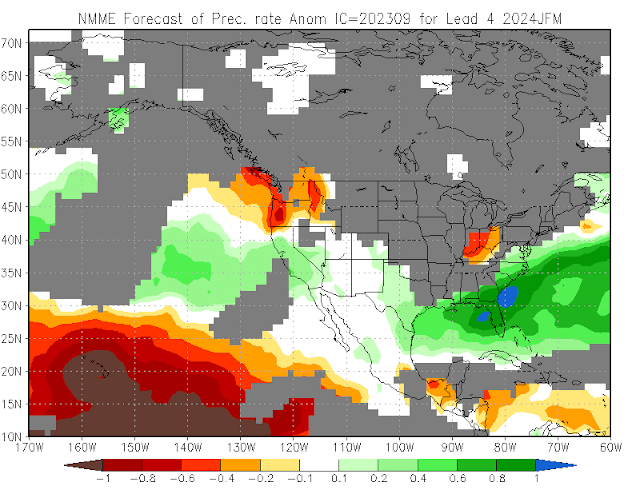
There are computer models that forecast the weather well into the future. And while we don't look at the specifics (e.g. an individual forecast for a particular date), we do average them together to get a general outlook. Here's what they are saying. It's important to note that the areas in grey are deemed "too low skill" to have any confidence. But for the Northwest, you can see that the confidence is high enough to show a dry and mild outlook.
So what does all of this mean for our neck of the woods? The last strong El Nino we had was the 2015-16 winter. That year Spokane received 34.2" of snow, compared to a normal of about 45". December 2015 was very wet (mostly rain) so the winter precipitation was actually 2" above normal. There were only 4 nights that Spokane's temperature fell below 10F, compared to a normal of 13 such days. But a series of colder storms during the few days before Christmas brought a good amount of snow to the Inland NW, and most of that snow stayed on the ground through the month of January.
Prior to that, the previous strong El Nino was the 1997-98 winter. Spokane received only 18.3" of snow that year, and precipitation was about 2" below normal. The high temperature remained below 30F for only 8 days that winter. A very mild winter indeed.
Of course, El Nino and La Nina don't guarantee an upcoming winter. They just tip the odds. Think of a deck of cards. Draw any card and it's a 50-50 chance it will be red or black. El Nino is like changing all of the spades to red, so the odds are now 75-25. But there's still a 25% chance of drawing a black card.
A few other publications have already weighed in on their winter outlooks. The Farmer's and Old Farmer's Almanacs (2 different publications) shown below don't agree with this blog.


.png)


Comments
Post a Comment