Hot Enough for You?
As expected, things got rather hot rather quickly in the Northwest. Spokane International hit 100F today, making this the 4th summer in a row of at least one triple-digit day. Is that some sort of record? No, just a notable number. Tomorrow (Wednesday) will likely be just as hot as today. In fact, Thursday probably won't see much cooling either. So if you're not a fan of the heat, you'll have to wait until Friday before things start to cool down.
Here's the weather pattern this afternoon (Tuesday). Hot ridge of high pressure over the Northwest US and southwest Canada. As I said in the previous blog, this pattern is fairly similar to our record-breaking heat wave a couple of years ago, just not quite as intense.
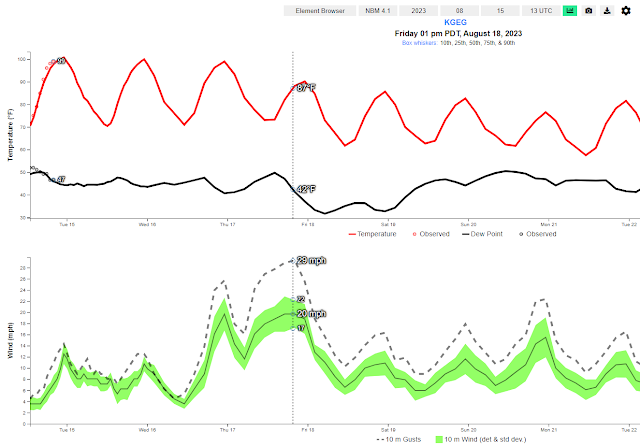
As is usually the case, the break down of a heat wave raises fire weather concerns. Be alert on Friday, as we could see a rather hot, dry, windy day. Yes, temperatures will be cooler, but the winds will be gusty and very dry air will be moving into the area. Here's the forecast for temperature and dew point (top graph) and winds (bottom graph). Note how the dew points drop into the low 30s by Friday afternoon while winds are gusting to 30 mph and temperatures are near 90F.
After that, an interesting weather pattern sets up. If you look back at the weather map for Friday, you'll see that in addition to the blue (cooler) trough in the Northwest, there's another cool trough moving into California at the same time. And then farther south, off the Mexican coast, there's a hurricane expected to form.
The hurricane will bring with it a surge of monsoon moisture into the desert Southwest. The California low will help draw that moisture even farther north, possibly into the Inland NW.
Here's what the atmospheric moisture anomaly will look like on Saturday. You can see the hurricane off of the Baja peninsula, with moisture streaming into Arizona and Nevada. But things are still dry in the Northwest.
Similar to our last summer rain event, this one will be equally tricky on timing, amounts and location. The earliest we might see rain from this pattern would be Saturday night. Chances of rain would increase on Sunday and Monday, continuing through Tuesday, before ending by Wednesday. As for location, the farther east you are, the better your odds of getting appreciable rainfall. Western Montana and the Idaho panhandle are almost sure bets. For those in the Cascades, the odds are much lower.
Here's the total rainfall forecast (Saturday night through Tuesday) from the European model.
Here's the same forecast from the US model. Very similar to the European forecast.
As with the previous rain event, there will be winners and losers again.
.png)


.png)
.png)
.png)
.png)
.png)
.png)


Comments
Post a Comment