Summer Outlook
After the warmest May ever, folks are probably wondering what (if anything) that will mean for our upcoming summer weather. The Climate Prediction Center (CPC) of the National Weather Service issues their climate outlooks once each month, on the third Thursday of the month. On the last day of the month, CPC updates their outlook for the upcoming month. So lets see what they are expecting for this summer.
Here's CPC's expectation for June. They expect June to be wetter and warmer than normal. You may find that a big strange, and it is. In the Northwest, cool and wet usually go together, as do warm and dry. Warm and wet is a bit unusual. But we need to remember that they don't have to occur at the same time. You can have a heat wave, followed by a wet period, which is what we're expecting for the first 10 days of the month.
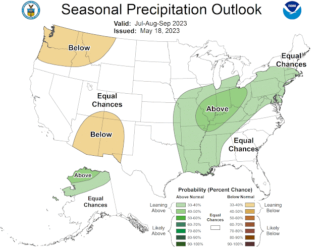
For the months of July, August and September, we see that CPC expects a warmer and drier than normal summer for us. Based on the weather trends of the last 20 years or so, this is the safe forecast for the Northwest.
Some of CPC's outlook comes from looking at six different climate models. Averaging them together, the mean (see below) looks a little different what we saw above. For precipitation, dry anomalies show up in the desert Southwest. So after last year's record rainy Southwest monsoon, the climate models aren't expecting a repeat this summer. But also notice the wet anomalies from southeast Oregon, across southern Idaho and into Montana. This is close to the Inland NW, and is somewhat similar to what we have been seeing for the past 30 days. While the models don't show a wet anomaly for our area, they also don't show a dry anomaly either. And some of the individual models do show a wetter than normal summer for the entire Northwest.
As most of you have heard, El Nino is developing in the Pacific, replacing the La Nina that has lasted for the past 3 years. And confidence is high that it will persist through the upcoming winter. First, let's look at a time series of Sea Surface Temperature (SST) anomalies since mid-March. In the movie below, you can see the warmer water (orange shading) developing along the equator from South America (on the right side of the image) out into the central Pacific. This is earlier than normal for an El Nino to develop.
There are climate models that predict these SST anomalies. If the anomaly reaches more than 0.5 degrees Celsius (about 1 degree Fahrenheit) for 3 consecutive months, an El Nino will be declared. If that anomaly reaches 1.0C, then it's a moderate strength, and a 1.5C anomaly means that we have a strong El Nino.Meanwhile, the Weather Channel (weather.com) is also going for a somewhat unique forecast. Their outlook is for dry in the West and wet in the East (which is typical).
Their temperature outlook actually shows Montana as the warmest anomaly, while California will be cooler than normal.
So what do we make of all of this? In my experience, summer outlooks are a little better than an educated guess. Sometimes they're correct by accident.
Summers have been trending warmer over the past 20 years. So if I was a betting man, I'd always bet on "warmer than normal". Here's the summer temperatures for the past 100+ years at Priest River. The blue line is the June-July-August average temperature, and the green line is a trend line. The trend line is going up (warmer) for the past 20 years.
Update
CPC came out with their new July/Aug/Sep outlook on Thursday 15 June. You can compare these to their previous outlook earlier in this blog.
While the temperature outlook didn't really change much, the precipitation outlook had some noteworthy changes. The chances for Above Normal precipitation has now been extended into Montana, Wyoming and eastern Idaho, while the Below Normal category has been pushed west of the Cascades. This agrees with what we were looking at earlier in this blog. So for the Inland Northwest, near-normal precipitation is the best bet for this summer.


.png)
.gif)
.png)


.png)
.png)
.gif)
.gif)
.png)


Comments
Post a Comment