Posts

Showing posts from April, 2023

Suddenly Summer

Image
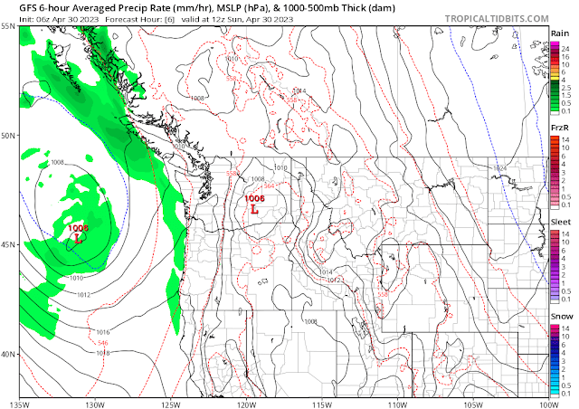
 Just a short week ago, the Inland Northwest was stuck in the cold spring weather, with afternoon temperatures failing to reach the 60F mark.  Then suddenly, the weather pattern flipped, and we're reaching the lower 80s.  Is the warm weather here to stay?  The short answer is "no".  Spring is a battle between winter and summer.  Summer always wins, but winter doesn't go down without a fight. Today will be borderline hot, with record temperatures for 30 April in jeopardy of being broken as highs reach into the mid-80s.  A low pressure system offshore will begin to spin clouds and showers over western Washington. By Monday morning, the low has moved onshore, and the clouds and showers have shifted into the Inland Northwest.  Atmospheric moisture will be rather high, so some of these showers and thunderstorms could bring heavy rain, especially to Okanogan county in north-central Washington.  All of this will result in a markedly cooler Monday. The rest of the week will b

Our first 70F day of the Spring

Image
 You've probably heard by now that the forecast for this week is for warmer and drier weather. But first, we'll have a showery Sunday and Monday. Morning showers will give way to afternoon/evening convective showers.  Here's the radar mosaic at 730am this Sunday morning: The forecast has a possibility of thunderstorms, but the vast majority of these will be south of Spokane.  Still, there is a small chance of thunderstorms over northeast Washington.  The dew point will climb into the upper 40s so any showers could put down a quick quarter of an inch of rain.  These showers will continue over northeast Washington tonight.  More showers are expected for Monday, but dew points will be much lower so rainfall from these Monday showers should be lighter Here is a computer forecast of the expected rainfall for Sunday and Monday.  Don't get too hung up about the exact amounts and placement.  But it does appear that northeast WA has the best chance for heavier rainfall, with som

Snow in the Forecast - for mid-April

Image
  Although the triple La Nina is officially over, the atmosphere is still looking rather La Nina-like in the Inland Northwest.  La Nina usually brings cool and wet weather to the Northwest during the spring months, so this is somewhat expected.  For the first half of April, temperatures in Deer Park were 2.7F below normal.  The figure below shows the daily temperatures at Deer Park Airport since Jan 1st.  The blue bars are the daily high/low.  The brown shading is normal, the red is above normal, and the blue is below normal.  As you can see, the blue bars have been hanging out more in the below-normal range than the above-normal. Precipitation for April so far has been 0.43" above normal at Deer Park.  But this actually followed three drier-than-normal months of January through March.  For the Water Year (which starts October 1st), Deer Park is drier than normal by nearly 2.5".  So while the wet April may be frustrating to farmers, we actually need the moisture.   The entire